Research

Doing the Math: Optimizing Routing and Scheduling for UAM Fleet Management Using Quantum Annealing
Finding the best solution to an optimization problem can help UAM operators
Writing in Scientific Reports, seven researchers from Japan’s Tohuku University and Sumitomo Corporation proposed a plan to optimize how urban air mobility (UAM) operators, infrastructure managers, and others in the UAM ecosystem manage routing and scheduling using quantum annealing. Quantum annealing, a quantum computing process, uses quantum fluctuations to find the best solution to an optimization…

What Can UAM Operators Do to Ensure They Gain Passengers’ Acceptance of Air Taxis?
Keep your passengers informed
A study conducted by the German Aerospace Center (DLR) reveals what is and isn’t important to gain passengers’ acceptance of urban air mobility (UAM) air taxi services. While the flights were simulated, the sentiments expressed were real. The researchers set up a mixed reality (MR) Air Taxi Simulator merging a real-world environment with a computer-generated…
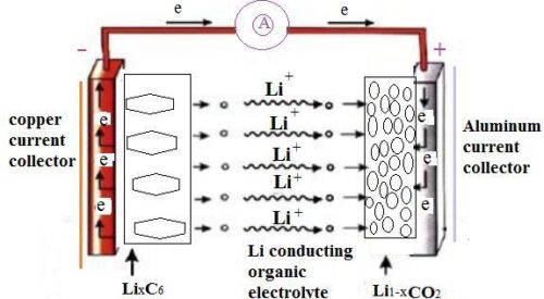
The Temperature’s Falling While the UAM Market Is Heating Up
The batteries used for UAM will need to cool down as well
At the heart of the impending urban air mobility (UAM) revolution are the electric vertical takeoff and landing (eVTOL) aircraft that will rise to the occasion to transport people and products from Point A to Point B. At the heart of those eVTOLs are the lithium-ion batteries powering their flight. Lithium-ion batteries, however, have an…

Getting Together – UAMs and NAS
Should the U.S. begin integrating UAM vehicles into the NAS now?
Writing in the Texas A&M Law Arguendo, Robert Notari, a Juris Doctor candidate, helicopter pilot, and certified flight instructor, raises the questions “AUTONOMY NOW?: IS IT TIME TO START INTEGRATING (AUTONOMOUS) URBAN AIR MOBILITY VEHICLES INTO THE NATIONAL AIRSPACE SYSTEM?” Inasmuch as auto manufacturers have yet to master autonomous-driving vehicles, it may be premature to ask…

What Can UAM Operators Do to Ensure They Gain Passengers’ Acceptance of Air Taxis?
Communicate, communicate, communicate
A study conducted by the German Aerospace Center (DLR) reveals what is and isn’t important to gain passengers’ acceptance of urban air mobility (UAM) air taxi services. While the flights were simulated, the sentiments expressed were real. The researchers set up a mixed reality (MR) Air Taxi Simulator merging a real-world environment with a computer-generated…