Droneports: Will Society Develop a NIMBY Approach?
EU Researchers propose a plan to ease the planning and development of landing and launch sites

We know by now that eVTOLs, crewed and uncrewed, are coming. But the question for many is ‘Where are they going? Specifically, where will they take off and land from – where should the landing and launch sites (LLS) be? Some site development plans in dense urban areas are obvious: a mid-town heliport can easily be used as a vertiport for passenger pickup and drop-off. Other site developments, especially for the multitudes of drones destined to take to the skies by the end of the decade, are potentially more controversial.
In the U.S. in the late 1970s and early 1980s an acronym was coined for development of commercial projects that many people would benefit from, but the ‘side effects’ – noise, increased traffic, crime – were unsavory to many residents whose lives would be impacted.
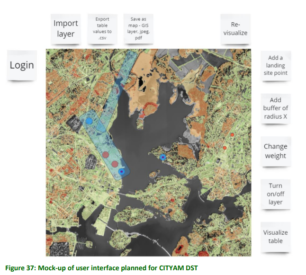
To better plan for the inevitable, the EU, as part of its Interreg Baltic Sea Region initiative and its CITYAM project, budgeted €3.72 million (about US$3.98 million) to produce a report, “Development of a geospatial decision[1]support tool for Urban Air Mobility (UAM) LLS site location planning.” Published in January 2024 and led by Aalto University and the Finnish Geospatial Research Institute, the objective was “to help establish regulations and integration of UAM in city planning using current and upcoming EU regulation and compares local regulations and regional policies in the partner countries of the project” (Estonia, Finland, Germany, Latvia, Poland, and Sweden). The CITYAM project specifically focuses on how to give cities the resources they need to manage the emerging UAM market and the drone operations they will produce.
Drone dynamics, metro-style
The study focused on helping key groups: hospitals and medical centers, infrastructure and public service providers, interested groups, local public authorities, and national public authorities. It limited its study to UAVs smaller than 3 meters (about 10 feet).
The factors impacting development of LLS include limitations on urban land use, the impact of drone technology use itself, unforeseen impacts, and a void in rules and regulations for operating drones within city limits. The need to develop a decision-support tool (DST) to support the onset of UAM operations prompted the study. The report elaborated on drone flight dynamics in urban settings, including “LLS access, design, and interaction with flight corridors.” The community-at-large would influence the DST development “based on the need to define the scope of the LLS planning process, assuming distributed responsibility among drone operators, the municipality and civil aviation authority.”

Here’s the plan for the planning
Drones come in two flavors, according to the researchers: “eye-in-the-sky” and “hand-in-the-sky.” The fluid and rapidly evolving adoption of drones into society will necessitate taking a multi-criteria analysis (MCA) approach.
The study concludes that an MCA framework is insufficient on its own. The project should be broken down into a phased approach which defines the roles and responsibilities of the various stakeholders. That ‘division of labor,’ the report suggests would benefit by appointing a a UAM planner to coordinate requests from UAV operators and help coordinate those needs with municipal planners and regulators. It’s a move away from traditional top-down technocratic process and will help the assuage the various stakeholders concerns that they will be able to operate safely, effectively, and profitably in these urban zones. Who could disagree with that?

Stay up-to-date with all things eVTOL, UAM, AAM, and UAVs.


